|
|
 |
 |
 |
||
|
|
|
|
|
|
|
||
|
|
|
FOREST COVER CHANGES IN CAMBODIA 2002-2006
1.1 Background The Royal Government of Cambodia (RGC) is committed to take action to strengthen sustainable environmental protection and management of the country's forest resources based on three important pillars, viz.,
To achieve environmental sustainability, the Cambodian Millennium Development Goal 7 has set benchmarks for 2015 related to forest resources:
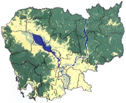
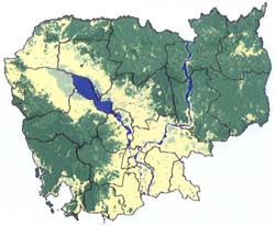
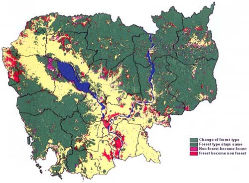
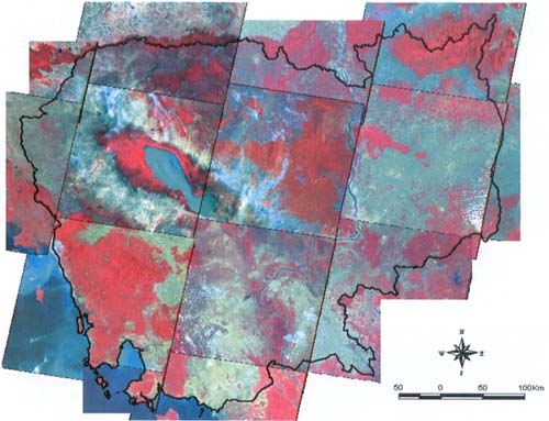
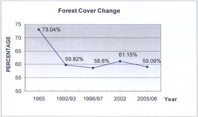
In December 2006 the Technical Working Group on Forestry and Environment (TWG F & E) adopted a four-year Forestry and Environment Action Plan 2007-2010 aligned with the National Strategic Development Plan, after an extensive consultative process. This provides a broad framework of prioritized actions and investment opportunities in the sector. 1.2 Changes in Cambodia's Forest Cover In 1965 forests covered an estimated 73 % of the country's territory. To monitor the loss of forestland, the Forestry Administration (FA) has conducted a series of forest cover assessments in 1992/93, 1996/97, 2000 (partial) and 2002. Cambodia's forest cover declined to an estimated 61% of the total land area in 2002. The loss of forest cover is consistent with land use and land cover change patterns associated with demographic growth and economic development in most countries. Critically, insecure title over land and unclear land use rights continue to hamper the efforts of Cambodia's rural poor to secure their livelihoods. Agricultural expansion, illegal logging, a construction boom and increasing demands for land associated with the growth in Foreign Direct Investment from S.E. Asia continue to result in the loss of forests, and the increased vulnerability of communities who depend on forest resources. There is clearly a need to ensure sustainable management and equitable use of forests, to improve rural livelihoods, and to promote a balanced socio-economic development in Cambodia. Past forest management systems have not contributed sufficiently to these broad policy objectives (Independent Forest Sector Review, 2004). 1.3 Forest Cover Change 2002-2006 The 10th TWG-F&E meeting held on 26 September 2006 agreed to support a national forest cover change assessment for 2005/06 with financial assistance provided by the Royal Danish Embassy-Danida. The Remote Sensing and Geographic Information System (RS-GIS) Unit within the FA’s Watershed Management and Forest Land Office conducted the forest cover change assessment using Landsat ETM+ data (Figure 1).1 (Documents available at www.twgfe.org). Figure 1: Landsat 7 satellite images
Independent quality assurance and data verification was carried out by GRAS A/S- University of Copenhagen. Their report concluded: (The) “RS and GIS unit is doing a very good job based on relatively simple mapping methods. However, several improvements can be made using the full multi-spectral capabilities of the satellite data that is difficult to do based alone on a manual classification. Shifting to more automated methods will ensure more systematic and consistent results"2. A three-stage capacity building plan to address these capacity constraints has already been put into effect.3 1.4 Summary of results
Table 1: Cambodian Forest Cover Estimates 1965-2006
Figure 2: Forest Cover Change, 1965-2006
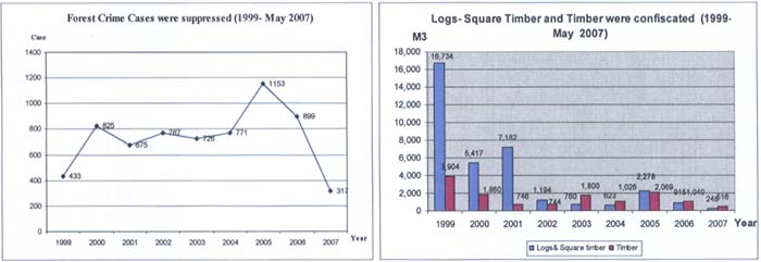
1.5 Conclusions The Forestry Administration's forest cover assessment for 2006/06 indicates that Cambodia lost 2% of its forest cover during the period 2002-2006, and not 29% as suggested in recent newspaper reports. The RGC continues its forestry reform and law enforcement activities as an integral part of the National Strategic Development Plan 2006-2010. These include activities which aim to improve the demarcating of the forest estate, up-scaling community forestry, protecting and managing a quarter of all forest land for conservation purposes, developing new service delivery models, undertaking pro-poor market studies, capacity development and internal forest crime monitoring. In the absence of Development Partner support for an independent monitor since early 2006 the FA has continued its own internal forest crime monitoring (Figure 3). Figure 3: Trends in FA Forest Crime Monitoring |
||||||||||||||||||||||||||||||||||||||||||||||||||||||||
 |
|
The Forestry Administration is committed to implement the RGC's policy and strategy for development of the forest sector. It strives to manage and conserve Cambodia's forests in a sustainable way whilst contributing to the alleviation of poverty of the rural people. The TWG F & E calls for all national and international development partners to continue their cooperation by supporting the national forest reform process. Appendix 1: Forest Cover Classification Evergreen forest: Evergreen forests are usually multi-storied forests where trees maintain their leaves during the whole year. They comprise the lowland tropical rain forests, the hill evergreen forests and the dry evergreen forest and along streams and rivers (gallery forests). Semi-evergreen forest: Semi-evergreen forests contain variable percentages of evergreen and deciduous trees, the percentage of evergreen trees varying from 30% to 70%. Semi-evergreen forests continue to appear evergreen throughout the year, even when the percentage of deciduous trees is high. Deciduous forest: Deciduous forests comprise dry mixed deciduous forests and dry Dipterocarp forests. Deciduous forests drop their leaves more or less completely during the dry season. Human impact such as fire is usually much higher compared to other forest types. Dry Dipterocarp forests naturally have an open character. As undisturbed deciduous forests may have a crown cover of only 40%, soil and grass may have a significant impact on reflections from these forests. As a result, it is difficult to separate deciduous forests from shrub land during the dry season. Other forests: This land cover type includes regrowth, stunted forests, mangrove forests, inundated forests, and forest plantations. Regrowth of secondary forests is representative of a continuous, usually dense, layer of smaller trees. Stunted forests grow very slowly because of poor site conditions on hydromorphic soils and rock outcrops. Heavily disturbed forest like mosaics of forest, regrowth, and cropping, corresponding to shifting agriculture in which the percentage of forest is more than 40%, and areas of old regrowth and young secondary forest in the process of regenerating after clear cutting, are also included in this category. Wood and shrub land evergreen: Wood and scrubland is a mixture of shrubs, grass and trees, the trees cover however remaining below 20 percent. This class can be found mainly on shallow soils, on the top of mountains under climax conditions or as a result of non sustainable land use. Theoretically there is a chance of becoming forest again. The signature remains light red during the whole year. Young regrowth after shifting cultivation is also included in this class when the shifting cultivation mosaic becomes invisible. There is usually a dense layer of shrub and grass with some trees. Wood and shrub land dry: A ‘Dry’ variant of this class can be found in dry plateaus, but also on dry and sun exposed slopes. The signature is light grey during the dry season and light brownish grey to violet during the wet season, the texture is medium to rough. Bamboo: Large areas of dense bamboo are usually discernible due to their pink and orange color and their typical texture. A sparse bamboo coverage or small bamboo will not be discernible and will remain in one of the other classes. Non forests: This category merges agricultural areas, urban areas, water bodies, grass land and barren land. |